Get help

Find out how you can share your stories, photographs and get the most out of the American Air Museum’s archive.

Explore how-to guides

About our archive

The American Air Museum's archive records the stories of the men and women of the US Army Air Forces who served in Britain and Europe during the Second World War.

Read more

Help searching

Can't find what you're looking for? Take a look at our search guide.

Read archive search guide

Research help

Our guides can help you to research the people, aircraft, places, missions, units, and media which make up your family history.

Explore research guides
Share this

We found 724 entries

Filter Results

Aerial photograph of Burtonwood airfield, 10 August 1945. Photograph taken by No. 541 Squadron, sortie number RAF/106G/UK/622. English Heritage (RAF Photography).
  • Media Type: Image
  • Collection Name: Historic England
  • Object Number: RAF_106G_UK_622_RP_3111
  • Description: Aerial photograph of Burtonwood airfield, 10 August 1945. Photograph taken by No. 541 Squadron, sortie number RAF/106G/UK/622. English Heritage (RAF...
Aerial photograph of Burtonwood airfield, 10 August 1945. Photograph taken by No. 541 Squadron, sortie number RAF/106G/UK/622. English Heritage (RAF Photography).
  • Media Type: Image
  • Collection Name: Historic England
  • Object Number: RAF_106G_UK_622_RS_4025
  • Description: Aerial photograph of Burtonwood airfield, 10 August 1945. Photograph taken by No. 541 Squadron, sortie number RAF/106G/UK/622. English Heritage (RAF...
Aerial photography of Bury St Edmunds (Rougham) airfield, looking south, under construction by Richard Costain Ltd, all three runways are incomplete, 24 December 1941. Photograph taken on sortie number RAF/2H/BR166. English Heritage (RAF Photography).
  • Media Type: Image
  • Collection Name: Historic England
  • Object Number: RAF_2H_BR166_VB_0005
  • Description: Aerial photography of Bury St Edmunds (Rougham) airfield, looking south, under construction by Richard Costain Ltd, all three runways are incomplete...
Aerial photography of the west end of Bury St Edmunds (Rougham) airfield, looking north, the firing butts and T2 hangar are either side of Eldohouse Farm in the centre of the image, 7 June 1946. Photograph taken by No. 540 Squadron, sortie number RAF/106G/UK/1557. English Heritage (RAF Photography).
  • Media Type: Image
  • Collection Name: Historic England
  • Object Number: RAF_106G_UK_1557_RS_4171
  • Description: Aerial photography of the west end of Bury St Edmunds (Rougham) airfield, looking north, the firing butts and T2 hangar are either side of Eldohouse...
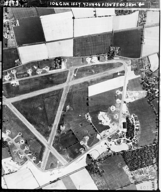
Aerial photography Bury St Edmunds (Rougham) airfield, looking north, the technical site and T2 hangar are to the right, 7 June 1946. Photograph taken by No. 540 Squadron, sortie number RAF/106G/UK/1557. English Heritage (RAF Photography).
  • Media Type: Image
  • Collection Name: Historic England
  • Object Number: RAF_106G_UK_1557_RS_4173
  • Description: Aerial photography Bury St Edmunds (Rougham) airfield, looking north, the technical site and T2 hangar are to the right, 7 June 1946. Photograph taken...
Aerial photography Bury St Edmunds (Rougham) airfield, looking west, the perimeter is under construction by Richard Costain Ltd, 8 May 1942. Photograph taken by No. 1 Photographic Reconnaissance Unit, sortie number RAF/HLA/537. English Heritage (RAF Photography).
  • Media Type: Image
  • Collection Name: Historic England
  • Object Number: RAF_HLA_537_V_6060
  • Description: Aerial photography Bury St Edmunds (Rougham) airfield, looking west, the perimeter is under construction by Richard Costain Ltd, 8 May 1942...
Aerial photography Bury St Edmunds (Rougham) airfield, looking south west, 29 December 1943. Photograph taken by 7th Photographic Reconnaissance Group, sortie number US/7PH/GP/LOC125. English Heritage (USAAF Photography).
  • Media Type: Image
  • Collection Name: Historic England
  • Object Number: US_7PH_GP_LOC125_V_5022
  • Description: Aerial photography Bury St Edmunds (Rougham) airfield, looking south west, 29 December 1943. Photograph taken by 7th Photographic Reconnaissance Group...
Aerial photograph of Chalgrove airfield, looking south west, the technical site with T2 hangar is at the bottom, 21 May 1944. Photograph taken by 7th Photographic Reconnaissance Group, sortie number US/7GR/LOC344. English Heritage (USAAF Photography).
  • Media Type: Image
  • Collection Name: Historic England
  • Object Number: US_7GR_LOC344_RS_4022
  • Description: Aerial photograph of Chalgrove airfield, looking south west, the technical site with T2 hangar is at the bottom, 21 May 1944. Photograph taken by 7th...
Aerial photograph of Chalgrove airfield, looking west, the technical site with T2 hangar is at the bottom, 13 August 1944. Photograph taken by 7th Photographic Reconnaissance Group, sortie number US/7GR/LOC389. English Heritage (USAAF Photography).
  • Media Type: Image
  • Collection Name: Historic England
  • Object Number: US_7GR_LOC389_VM_8027
  • Description: Aerial photograph of Chalgrove airfield, looking west, the technical site with T2 hangar is at the bottom, 13 August 1944. Photograph taken by 7th...
Aerial photograph of the north end of Chalgrove airfield, looking west, B-26 Marauders are parked on the hard standing, 13 August 1944. Photograph taken by 7th Photographic Reconnaissance Group, sortie number US/7GR/LOC389. English Heritage (USAAF Photography).
  • Media Type: Image
  • Collection Name: Historic England
  • Object Number: US_7GR_LOC389_VM_8045
  • Description: Aerial photograph of the north end of Chalgrove airfield, looking west, B-26 Marauders are parked on the hard standing, 13 August 1944. Photograph...
Aerial photograph of Chalgrove airfield, looking west, the perimeter is under construction, 15 August 1943. Photograph taken by 7th Photographic Reconnaissance Group, sortie number US/7PH/GP/LOC22. English Heritage (USAAF Photography).
  • Media Type: Image
  • Collection Name: Historic England
  • Object Number: US_7PH_GP_LOC22_V_1035
  • Description: Aerial photograph of Chalgrove airfield, looking west, the perimeter is under construction, 15 August 1943. Photograph taken by 7th Photographic...
Aerial photograph of Chalgrove airfield, looking south, the perimeter is under construction, Chalgrove village is to the right of the airfield, 11 September 1943. Photograph taken by 7th Photographic Reconnaissance Group, sortie number US/7PH/GP/LOC41. English Heritage (USAAF Photography).
  • Media Type: Image
  • Collection Name: Historic England
  • Object Number: US_7PH_GP_LOC41_V_5038
  • Description: Aerial photograph of Chalgrove airfield, looking south, the perimeter is under construction, Chalgrove village is to the right of the airfield, 11...
Aerial photograph of Chalgrove airfield, looking west, Chalgrove village is at the top of the image, 2 December 1943. Photograph taken by 7th Photographic Reconnaissance Group, sortie number US/7PH/GP/LOC93. English Heritage (USAAF Photography).
  • Media Type: Image
  • Collection Name: Historic England
  • Object Number: US_7PH_GP_LOC93_V_5009
  • Description: Aerial photograph of Chalgrove airfield, looking west, Chalgrove village is at the top of the image, 2 December 1943. Photograph taken by 7th...
Aerial photograph of Chalgrove airfield, looking north west, the technical site with T2 hangar is towards the bottom right, 2 December 1943. Photograph taken by 7th Photographic Reconnaissance Group, sortie number US/7PH/GP/LOC93. English Heritage (USAAF Photography).
  • Media Type: Image
  • Collection Name: Historic England
  • Object Number: US_7PH_GP_LOC93_V_5061
  • Description: Aerial photograph of Chalgrove airfield, looking north west, the technical site with T2 hangar is towards the bottom right, 2 December 1943...
Aerial photograph of Chalgrove airfield, looking north west, the technical site with T2 hangar is towards the bottom right, 2 December 1943. Photograph taken by 7th Photographic Reconnaissance Group, sortie number US/7PH/GP/LOC93. English Heritage (USAAF Photography).
  • Media Type: Image
  • Collection Name: Historic England
  • Object Number: US_7PH_GP_LOC152_V_5010
  • Description: Aerial photograph of Chalgrove airfield, looking north west, the technical site with T2 hangar is towards the bottom right, 2 December 1943...
Aerial photograph of Chalgrove airfield, looking south east, Chalgrove village is in the centre of the image, 7 March 1944. Photograph taken by 7th Photographic Reconnaissance Group, sortie number US/7PH/GP/LOC206. English Heritage (USAAF Photography).
  • Media Type: Image
  • Collection Name: Historic England
  • Object Number: US_7PH_GP_LOC206_V_5012
  • Description: Aerial photograph of Chalgrove airfield, looking south east, Chalgrove village is in the centre of the image, 7 March 1944. Photograph taken by 7th...
Aerial photograph of the north end of Stoney Cross airfield looking west, the runways and perimeter are under construction, 29 April 1942. Photograph taken by sortie number RAF/13T/AC49. English Heritage (RAF Photography).
  • Media Type: Image
  • Collection Name: Historic England
  • Object Number: RAF_13T_AC49_V_0013
  • Description: Aerial photograph of the north end of Stoney Cross airfield looking west, the runways and perimeter are under construction, 29 April 1942. Photograph...
Aerial photograph of the west end of Stoney Cross airfield looking north, a dispersal area is at the bottom, 21 September 1946. Photograph taken by No. 541 Squadron, sortie number RAF/CPE/UK/1749. English Heritage (RAF Photography).
  • Media Type: Image
  • Collection Name: Historic England
  • Object Number: RAF_CPE_UK_1749_RP_3270
  • Description: Aerial photograph of the west end of Stoney Cross airfield looking north, a dispersal area is at the bottom, 21 September 1946. Photograph taken by No...
Aerial photograph of the east end of Stoney Cross airfield looking north, the control tower, airfield code and technical site are to the right, 21 September 1946. Photograph taken by No. 541 Squadron, sortie number RAF/CPE/UK/1749. English Heritage (RAF Photography).
  • Media Type: Image
  • Collection Name: Historic England
  • Object Number: RAF_CPE_UK_1749_RP_3271
  • Description: Aerial photograph of the east end of Stoney Cross airfield looking north, the control tower, airfield code and technical site are to the right, 21...
Aerial photograph of Stoney Cross airfield looking south, the runway and perimeter are under construction, 2 June 1942. Photograph taken by No. 1 Photographic Reconnaissance Unit, sortie number RAF/HLA/567. English Heritage (RAF Photography).
  • Media Type: Image
  • Collection Name: Historic England
  • Object Number: RAF_HLA_567_V_6061
  • Description: Aerial photograph of Stoney Cross airfield looking south, the runway and perimeter are under construction, 2 June 1942. Photograph taken by No. 1...